TOKYO’S HISTORY, GEOGRAPHY, AND POPULATION
Geography of Tokyo
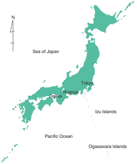
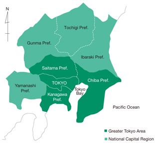
Tokyo Metropolis is located in the southern Kanto region, positioned in approximately the center of the Japanese archipelago. It is bordered to the east by the Edogawa River and Chiba Prefecture, to the west by mountains and Yamanashi Prefecture, to the south by the Tamagawa River and Kanagawa Prefecture, and to the north by Saitama Prefecture.
The Tokyo Megalopolis Region, or Greater Tokyo Area, is made up of Tokyo and the three neighboring prefectures of Saitama, Chiba, and Kanagawa. This area is home to around 30% of Japan’s total population. The National Capital Region is made up of Tokyo and the seven surrounding prefectures of Saitama, Chiba, Kanagawa, Ibaraki, Tochigi, Gunma, and Yamanashi.
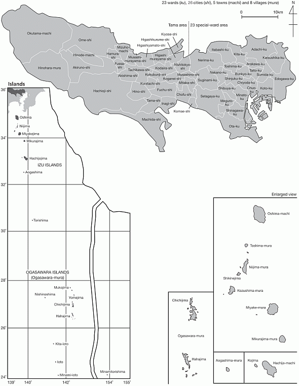
Tokyo Metropolis is a metropolitan prefecture comprising administrative entities of special wards and municipalities. The “central” area is divided into 23 special wards (ku in Japanese), and the Tama area is made up of 26 cities (shi), 3 towns (machi), and 1 village (mura). The 23 special-ward area and the Tama area together form a long, narrow stretch of land, running about 90 kilometers east to west and 25 kilometers north to south. The Izu Islands and the Ogasawara Islands, two island groups in the Pacific Ocean, are also administratively part of Tokyo, despite being geographically separated from the metropolis. The islands have between them two towns and seven villages. In addition, islands comprising the most southern and most eastern lands of Japan also fall under the administrative district of Ogasawara-mura; these are, respectively, the Okinotorishima Islands, which have an exclusive economic zone of about 400,000 square kilometers, and Minamitorishima Island.
The overall population of Tokyo is about 13.49 million (as of October 1, 2015), and the area is about 2,191 square kilometers. The climate is generally mild.
Map of Japan
Tokyo Metropolis and Surrounding Prefectures
The 23 Special-ward Area
The total area covers about 627 square kilometers. The population has been showing an upward trend, with 9.24 million residents—a population density of about 14,746 persons per square kilometer—as of October 1, 2015.
The 23 special-ward area is the political, economic, and cultural hub of Japan. Government offices, corporations, and commercial facilities are concentrated in the heart of Tokyo, and the transportation network is well developed. The bay area is a transportation and logistics hub, with regional transportation infrastructure that includes a major international airport and port. Cultural facilities such as museums and art galleries, as well as sightseeing and entertainment facilities, are located in the 23 special-ward area, making it an area bustling with large numbers of visitors.
The Tama Area
The Tama area covers about 1,160 square kilometers. Its population is 4.22 million—a population density of about 3,640 persons per square kilometer—as of October 1, 2015.
This area is urbanized as it is adjacent to the ward area, but also has a beautiful natural environment including lakes, rivers, and green areas. Moreover, strong industrial capability and rich human resources made available through the concentration of universities, high-tech industries, and research institutes, make this area a region with high potential. The Tama area has an important position within not only Tokyo Metropolis, but the entire Greater Tokyo Area as well.
The Islands
The islands have a total area of about 404 square kilometers. The island population is continuing to fall and currently stands at 26,000 (as of October 1, 2015), with a population density of 65 persons per square kilometer.
This region has a rich natural environment abundant with marine resources, and the islands also play an important national role in securing a vast exclusive economic zone. They have a diverse and remarkable natural environment, as well as a unique historical and cultural background, and are precious assets providing valuable “healing” spaces for visitors. On the other hand, the islands face challenges such as improving living conditions through development of the marine and air transportation network and medical care, a declining and aging population, and sluggish agriculture, fisheries, and tourism industries.
Administrative Areas of Tokyo